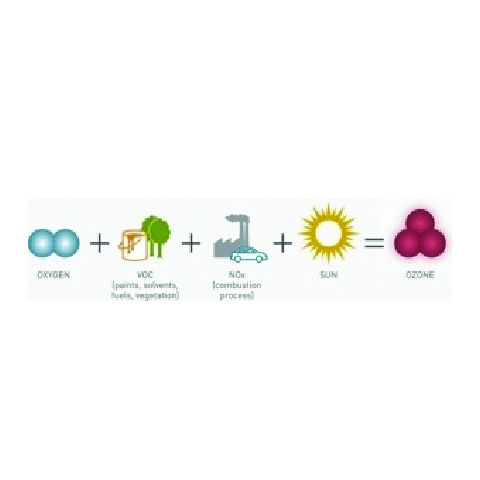


ABS: Section 182(c)(1) of the 1990 Clean Air Act Amendments (CAAA) required the Administrator to promulgate rules for the enhanced monitoring of ozone, oxides of nitrogen (NOx), and volatile organic compounds (VOC) to obtain more comprehensive and representative data on ozone air pollution.
Background
Section 182(c)(1) of the 1990 Clean Air Act Amendments (CAAA) required the Administrator to promulgate rules for the enhanced monitoring of ozone, oxides of nitrogen (NOx), and volatile organic compounds (VOC) to obtain more comprehensive and representative data on ozone air pollution. Immediately following the promulgation of such rules, the affected States were to commence such actions as were necessary to adopt and implement a program to improve ambient monitoring activities and the monitoring of emissions of NOx and VOC. Each State Implementation Plan (SIP) for the affected areas must contain measures to implement the ambient monitoring of such air pollutants. The subsequent revisions to Title 40, Code of Federal Regulations, Part 58 (40 CFR 58) required States to establish Photochemical Assessment Monitoring Stations (PAMS) as part of their SIP monitoring networks in ozone nonattainment areas classified as serious, severe, or extreme.
The principal reasons for requiring the collection of additional ambient air pollutant and meteorological data are the lack of attainment of the National Ambient Air Quality Standard (NAAQS) for ozone nationwide, and the need for a more comprehensive air quality database for ozone and its precursors.
The chief objective of the enhanced ozone monitoring revisions is to provide an air quality database that will assist air pollution control agencies in evaluating, tracking the progress of, and, if necessary, refining control strategies for attaining the ozone NAAQS. Ambient concentrations of ozone and ozone precursors will be used to make attainment/nonattainment decisions, aid in tracking VOC and NOx emission inventory reductions, better characterize the nature and extent of the ozone problem, and prepare air quality trends. In addition, data from the PAMS will provide an improved database for evaluating photochemical model performance, especially for future control strategy mid-course corrections as part of the continuing air quality management process. The data will be particularly useful to States in ensuring the implementation of the most cost-effective regulatory controls.
Data Quality Objectives
Data Quality Objectives (DQOs) are statements that relate the quality of environmental measurements to the level of uncertainty that decision-makers are willing to accept for results derived from the data. It is never possible to be absolutely certain that a future data set will satisfy the data needs exactly. There is always a chance that variables, variation, and uncertainty beyond the program’s control will lead to a “softness” in the data and a resulting uncertainty that the subsequent decisions are appropriate. For example, it is not possible to be 100% certain that a downward trend in ozone concentration has been confirmed or denied, since it is possible that local meteorology unexpectedly affected the two highest-reading days, one way or the other. By carefully designing the equipment and schedules, however, it is possible to reduce to acceptable levels the possibility of making an erroneous call.
- Objective 1– Provide a speciated ambient air database which is both representative and useful for ascertaining ambient profiles and distinguishing among various individual VOC. These data can later be used as evaluation tools for control strategies, cost-effectiveness, and for understanding the mechanisms of pollutant transport.
- DQO #1.1 The data for any given pollutant measured at a PAMS site must be able to show the presence of a diurnal pattern, if one exists, with an 80% confidence level.
- DQO #1.2 The data for any given pollutant measured at a PAMS site must be able to show a change in the diurnal pattern, if a change exists, with an 80% confidence level.
- Objective 2– Provide local, current meteorological and ambient data to serve as initial and boundary condition information for photochemical grid models. These data can later be used as a baseline for model evaluation and to minimize model adjustments and reliance on default settings.
- DQO #2.1 The speciated VOC, ozone, NOx and meteorological data must satisfy the regulations, including monitor siting, operation, and data quality criteria.
- Objective 3– Provide a representative, speciated ambient air database which is characteristic of source emission impacts. These data can be particularly useful in analyzing emissions inventory issues and corroborating progress toward attainment.
- DQO #3.1 The monitoring data for Total Volatile Organic Compound (Total VOC) concentrations collected at #2 Sites must be able to demonstrate a 3% annual trend (upward or downward) over a 5-year monitoring period, if it exists, with an 80% confidence level.
- DQO #3.2 The speciated VOC monitoring data collected at a #2 Site, when composited into categories, must be able to demonstrate a 20% change (upward or downward) in the seasonal average between two consecutive years, if it exists, with an 80% confidence level.
- Objective 4– Provide ambient data measurements which would allow later preparation of unadjusted and adjusted pollutant trends reports.
- DQO #4.1 The composite monitoring data for a given MSA/CMSA for ozone, NOx, and speciated VOC must be able to demonstrate a yearly downward trend with an 80% confidence level until an area achieves attainment.
- Objective 5– Provide additional measurements of selected criteria pollutants. Such measurements can later be used for attainment/nonattainment decisions and to construct NAAQS maintenance plans.
- DQO #5.1 The ozone (and NO2 where appropriate) monitoring data must satisfy the criteria specified in the NAMS and SLAMS monitoring regulations, including monitor siting, operation, and data quality criteria.
- Objective 6– Provide additional measurements of selected criteria and non-criteria pollutants from properly-sited locations. Such measurements can later be used for evaluating population exposure to air toxics as well as criteria pollutants.
- DQO #6.1 The speciated VOC monitoring data must be able to provide annual average concentration data at #2 Sites to within +/-50%, with a confidence level of 80%.
PAMS Site Descriptions
The PAMS network array for an area should be fashioned to supply measurements which will assist States in understanding and solving ozone nonattainment problems. EPA has determined that for the larger areas, the minimum network which will provide data sufficient to satisfy a number of important monitoring objectives should consist of five sites:


Site #1 – Upwind and background characterization site. These sites are established to characterize upwind background and transported ozone and its precursor concentrations entering the area and will identify those areas which are subjected to overwhelming incoming transport of ozone. The #1 Sites are located in the predominant morning upwind direction from the local area of maximum precursor emissions and at a distance sufficient to obtain urban scale measurements. Typically, these sites will be located near the upwind edge of the photochemical grid model domain.
Site #2 – Maximum ozone precursor emissions impact site. These sites are established to monitor the magnitude and type of precursor emissions in the area where maximum precursor emissions representative of the MSA/CMSA are expected to impact and are suited for the monitoring of urban air toxic pollutants. The #2 Sites are located immediately downwind (using the same morning wind direction as for locating Site #1) of the area of maximum precursor emissions and are typically placed near the downwind boundary of the central business district (CBD) or primary area of precursor emissions mix to obtain neighborhood scale measurements. Additionally, a second #2 Site may be required depending on the size of the area, and should be placed in the second-most predominant morning wind direction.
Site #3 – Maximum ozone concentration site. These sites are intended to monitor maximum ozone concentrations occurring downwind from the area of maximum precursor emissions. Locations for #3 Sites should be chosen so that urban scale measurements are obtained. Typically, these sites are located 10 to 30 miles from the fringe of the urban area.
Site #4 – Extreme downwind monitoring site. These sites are established to characterize the extreme downwind transported ozone and its precursor concentrations exiting the area and will identify those areas which are potentially contributing to overwhelming ozone transport into other areas. The #4 Sites are located in the predominant afternoon downwind direction from the local area of maximum precursor emissions at a distance sufficient to obtain urban scale measurements. Typically, these sites will be located near the downwind edge of the photochemical grid model domain.
Areas Subject to PAMS
In 1997, the revision to the O3 NAAQS set forth that the 1-hour standards will no longer apply to an area once EPA determines that the area has air quality data meeting the 1-hour standards. Subsequent to that change, EPA revoked the 1-hour O3 NAAQS in most counties in the United States, leaving 226 counties (and 38 nonattainment areas) where the 1-hour standard still applies. Currently, 24 of the 38 1-hour ozone nonattainment areas are classified as either serious, severe, or extreme and hence, are subject to PAMS. The 24 areas have a total population of about 84 million people. Because the flexibility of the PAMS regulations allow areas in close proximity to one another to consolidate their monitoring operations, only 22 operating networks actually exist. See Area List and table endnotes in the Networks and Sites section.
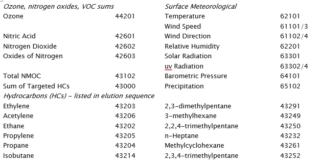
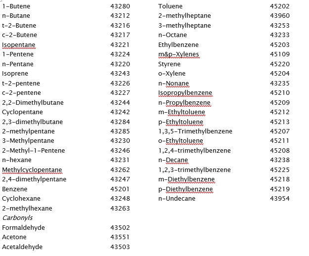
PAMS Target Parameters
The data collected at the PAMS sites include measurements of O3, NOx, a target list of VOCs including several carbonyls, as well as surface and upper air meteorology. Most PAMS sites measure 56 target hydrocarbons on either a hourly or 3-hour basis during the O3 season. The Type 2 sites also collect data on 3 carbonyl compounds (formaldehyde, acetaldehyde, and acetone) every three hours during the O3 monitoring period. Included in the monitored VOC species are ten compounds classified as hazardous air pollutants (HAPs). All stations must measure O3, NOx, and surface meteorological parameters on an hourly basis. Below are the parameters monitored at the surface PAMS sites.